
Gather intel with Cutting-Edge UAV Technology
Operating under CAA Part 102
Our Services

Thermal Imaging
With the latest and most advanced equipment currently available in the market, we can effectively leverage this cutting-edge technology to reveal potential problems from both the ground and the air. Detailed reports are meticulously compiled by our highly qualified and registered Level 3 Thermographer, ensuring precision and reliability in every analysis.

Drone Mapping
Drone mapping uses UAVs to create high-resolution terrain maps, capturing spatial data swiftly to enhance project accuracy and decision-making. It benefits agriculture, construction, environmental monitoring, and disaster response by modernizing traditional surveying through rapid data collection, reduced costs, and improved detail. By producing 2D and 3D models, it allows industries to visualize and analyze landscapes for smarter, sustainable development.

Inspections
Drones have transformed electrical equipment inspections across industries. With high-resolution cameras, they capture detailed images of power lines, transformers, buildings and infrastructure, reaching areas that are difficult to access. This approach minimizes time-consuming and dangerous manual inspections while quickly identifying issues like overheating or structural damage. Consequently, drones enhance safety and reliability in electrical operations.
Equipment
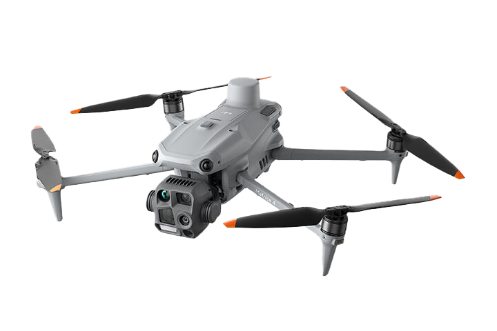
DJI Matrice 4T - released 2025
We are utilizing the latest advancements in aerial thermal imaging technology with the DJI Matrice 4T. This drone represents the perfect balance of compact size, rapid deployment speed, and exceptionally accurate imaging capabilities. However, what truly sets us apart is our extensive skill set, industry qualifications, and years of experience, all of which empower us to operate this impressive equipment effectively and efficiently.
Features:
3 optical cameras - wide, medium and telephoto
Radiometric thermal camera
Laser range finder for measuring distance
RTK enabled for precision location data
About
our company
We have combined the leading thermal imaging expert with one of the most experienced drone operators in the country. That means we can provide unparalleled expertise in this field.
Brad is the man behind Thermal Imaging Services and holds a Level 3 Master Thermographer certificate from the ITC. For the last 15 years he has been the main service provider for the electrical companies in Auckland and factories around the country
Chris has been operating drones for a decade and hasn’t crashed one yet! From small pocket sized drones to large heavy lifters, he knows how to operate them safely and effectively, and most importantly, in accordance with CAA regulations.
Drone Intel operates under Part 102. This means that we can legally operate drones where others can not. Close to airports, above 120m and at night.

FAQ
-
What kind of inspections do you offer?
We specialise in thermal imaging, aerial mapping, and high-resolution visual inspections. Our drone services are ideal for applications across the energy sector, infrastructure monitoring, construction, agriculture, and asset management.
-
What is thermal imaging, and why is it useful?
Thermal imaging uses infrared sensors to detect heat signatures. This allows us to identify issues such as heat loss, electrical faults, or moisture ingress, problems that are often invisible to the naked eye. It’s especially useful for inspecting solar panels, substations, buildings, and pipelines.
-
What types of mapping do you provide?
We offer 2D orthomosaic maps, 3D models, and digital elevation models (DEMs) generated from high-resolution drone imagery. These are valuable tools for site planning, construction progress, land development, and infrastructure maintenance.
-
How accurate is your mapping?
Our mapping workflows use RTK (Real-Time Kinematic) enabled drones and ground control points (GCPs) for enhanced precision. Depending on site conditions and project requirements, we can achieve centimetre-level accuracy.
-
Can you inspect live electrical assets?
Yes. Our drones allow us to safely inspect live electrical infrastructure, such as transmission lines, transformers, and substations, without needing to shut down equipment. Thermal and zoom-enabled imaging help us spot potential issues from a safe distance.
-
What resolution are your inspections captured at?
Our drones are equipped with high-resolution cameras, capturing stills up to 48MP and video in 4K and higher. This enables us to detect fine detail such as corrosion, cracks, or loose fittings on towers, roofs, and industrial assets.
-
Do you provide reports with your inspections?
Yes. We deliver detailed visual and thermal reports tailored to your needs. These may include annotated images, measurement data, georeferenced maps, and issue tracking to streamline maintenance and decision-making.
-
Are your pilots certified?
Yes. Drone Intel operates under a Part 102 exposition and all drone operations are carried out by CAA-certified pilots in full compliance with New Zealand’s aviation regulations. Safety and reliability are at the core of everything we do.
-
Can you inspect hard-to-reach areas?
Absolutely. Drones allow us to safely inspect roofs, towers, bridges, and confined or hazardous environments—eliminating the need for scaffolding, rope access, or costly shutdowns.
-
Where do you operate?
While we are based in Auckland, we are regularly carrying out inspections around the country. This allows us to group work together to cut costs. And our Part 102 exposition means that we can operate close to airports and aerodromes, at heights above 120m, over private property and beyond visual line of sight.
-
What does it cost?
Every project is different and so we will quote based on the requirements and the reporting to be delivered. It’s best to get in touch and have a chat about your project. But rest assured that we are very experienced and therefore fast. It is our main priority to deliver value for our clients.
-
What's the best way to discuss a project and get started?
Either fill out the contact form, send us an email at contact@droneintel.co.nz, or go old school and pick up the phone. We’re here to help and would love to discuss your project.
Contact Us
Interested in working together? Fill out some info and we will be in touch shortly. We can’t wait to hear from you!